|
Nishinomiya
At
the end of June 1945 the major cities of the Empire were in ruins.
All during the month of July the medium sized cities were systematically
destroyed and at month’s end the target list was nearing
zero. The decision came down to intensify the campaign and conduct
an all out blitz on the targets remaining.
The
raids would be burn jobs, striking between 2300 and 0300 hours.
During the day a target list was broadcast to Japan, notifying
them that some would be hit that night. The object was to compel
evacuation of all the areas though not all would be hit. On 27/28
July, eight targets were hit by a force of 571 B29s. On 1/2 August,
784 B29s bombed six targets. On 5/6 August 602 B29s bombed six
targets. 250 of this number rained napalm on the city of Nishimomiya.
Not
the entire built up areas of cities were targeted, only the areas
that were of strategic importance. Nishinomiya was a city of 10
square miles and 4.5 square miles were targeted. The city was
long and narrow (see map), and at most 2 miles wide before its
elevation rose to 1000 feet. In 1945 its population was 112,000
and it was a vital link between the destroyed cities of Kobe and
Osaka. It’s rail line, port, and manufacturing facilities
were still functional. It was and still is best known for the
production of a high quality Sake. Sake was an important part
of the Banzai and Kamikaze rituals adding to its strategic importance.
Of the 4.5 square miles targeted 3.5 square miles were destroyed.
This represented 64% of the targeted area and 36% of the built
up area of the city.
The
combination of Radar and the Norden Bomb Sight was the key to
the success of Air Offensive Japan. We are fortunate to have a
series of nine radar scope photos taken on the Nishinomiya raid.
They were taken at the Navigator’s repeat scope and were
supplied to the 39th Bomb Group Association by Captain Ralph Weston,
A/C of Crew 41, 62nd Squadron, 39th Bomb Group, 314th Wing. They
are reproduced in the pages following with analytical comments.
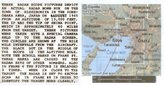
Navigation
Chart of the Kobe Osaka area. The Bomb Run began at I Shima,
the Initial Point (IP). The Radar image shows the position
of the aircraft in the center of the image about 15NM northeast
of I Shima and position 2 on the map flying at a true heading
of 28 degrees. |
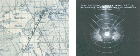
Image
on left shows the aircraft at Position 1 on the navigation
chart, having cleared the IP at Chima Point and entering
South Osaka Bay on a heading of 28 degrees, and an altitude
of 13,000 feet. Image on right shows the aircraft in the
middle of South Osaka Bay, position 2 on the map, headed
for the narrows beween the upper and lower bays. |
|